From my old files
 rough trail
 This is a trail?
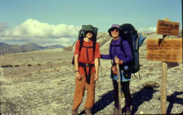
 Plains of Abraham
 Steep
Steep
 Blueberries fall colors
 Blueberry tongues
 Camp at Plains of Abraham
 the mountain herownself


Hiking Circles around Mt. St. Helens
October, 2000
One of the advantages of hiking in the Pacific Northwest, as opposed to our usual venue of desert, is that there is abundant drinking water. So of course we elected to do a hike with no water at all. Well, almost no water at all.I wanted to hike the Timberline Trail around Mt. Hood, but Brad has wanted to hike around St. Helens ever since it blew up, and Robbie wanted to do the hike that was shorter, so I was outvoted. I went to REI to buy a map, and the clerk said, "You're hiking St. Helens this late in the year?"
I replied naively, "I know the weather can change quickly, but it's forecast to clear up, and we always carry extra gear."
"Well, I think it's a good idea for people to hike our mountains in the fall. It keeps them humble." And with an evil laugh he vanished into the back room.
With that cheerful note, we packed enough clothes to see us through a minor blizzard and four days worth of food for a three day hike. The route we planned was 30 miles, which would normally figure to 10 miles a day, but there is no camping in the "blast zone". The zone is 9.5 miles wide, and there is no water for at about a mile on either side. That means the second day would be at least 11.5 miles.
One book I read recommended hiking clockwise, and one recommended counterclockwise. It is helpful when experts agree. We figure it's always nice to get the longest day out of the way, so we gathered at June Lake bright and early and started out clockwise on the Loowit Trail. The books had also warned that the trail was "new", rugged, poorly marked, and harder than it sounds. Since we are pretty strong and experienced, we figured we should be able to hold about 2.5 MPH, which is about what we do in the Grand Canyon. Once we hit the first lava flow, we had to re-figure to 1.5 MPH, which is closer to what we do off-trail in the GC.
I had opted not to carry a hiking stick on the plane (it wouldn't fit under the seat anyhow), and wasn't inclined to pay $25 for one at Jack's, where we picked up our parking permit (no hiking permits required yet), so I planned to pick up a hiking stick on the way. Well, those NW sticks are too skinny and crooked, and I hit the first lava flow with a forty-pound pack and no stick. I could feel those old "balance" muscles as I hip-hopped across the rocks. In the midst of the second flow, I found a stick abandoned right in the middle of the trail. That made things easier.
We hiked through odds and ends of old-growth forest and across a few lava flows, then climbed almost to 4800 feet to meet the summit trail. We saw one hiker silhouetted against the ridge on his way to the summit. That was the only hiker we saw in three days.
We were traveling much slower than we had planned. We find that if we stop for a packs-off rest about once an hour or so we make better time, but I do like to stop at an obvious goal. I was waiting for the next "feeder" trail to come up before I stopped so I would know how far we had hiked. I saw a wooden sign on the next ridge. Every other trail had a wooden sign, so I thought: "Good. There's the next trail, so we stop here." After our rest I climbed to the sign and it read "Practice Leave no Trace Camping". I do, and I'm glad they want everyone else to, but that was a shocker. We had stopped almost a mile short of where I'd wanted to rest.
We finally made it to the Toutle River, the last water source before the blast zone and a 11.5 mile day from the June Lake Trailhead. It was a steep, long climb down into the river bed. At one point I was declaiming to Robbie (educational time) that on St. Helens, most of the water soaked into the pumice like a sponge, whereas on a normal mountain, there would be rivulets of water running down every slope. I pointed up to demonstrate and found myself staring face to face with a bear. Well, it was about a tenth of a mile way, but still...
We got a little excited about that, and decided that at least it wasn't a mother with a cub when a SECOND bear appeared. Hmmm, either twin cubs, or a mother with a real-ly big baby. They gave me a dirty look and waddled off up the hill looking for berries, and we proceeded downhill making a lot more noise than we had been previously.
The clouds had been playing peek-a-boo all day, and they lowered ominously as the night drew on. I had to climb down a deep cut in the mud to fill my water container, but the water was fairly clear. I had been warned about ash and pumice in the water clogging up the filter, so I brought our Katadyne filter. It is heavy, awkward, and slow, but it will purify raw sewage, and when it clogs you can scrub it clean in un-purified water. As it turned out, there was little or no snow melt so I did find fairly clear water. I could definitely see how one could run into trouble earlier in the year as runoff carried more crud into the stream. Since we entered the river bed we had been on pumice and mud deposited by the massive floods following the 1980 eruption.
What with our neighboring bears and all we wanted to hang the food well, but you have to hang food at least 40 feet off the ground to keep it safe from bears, and the only tree in the area was 10 feet high. We got it was high as we could, and hoped that these were not "garbage" bears. Or maybe our pitiful "bear-proof" setup would lead them to paroxysms of laughter and we would hear them in time to chase them off. Since we had heard no warnings, we figured they were probably more interested in the berries than freeze-dried stroganoff. We were plenty warm enough in the tent. I had to listen to the usual nonsense about bringing the "small" tent to save weight. However I had also been listening to the usual nonsense about how heavy the packs were, so does anyone see a problem with this?
All night the wind sounded like rain on the tent, so I steeled myself to face fog, rain, sleet and maybe a small blizzard when I unzipped in the morning. Instead -- sunrise! Blue sky! It cleared up! We packed quickly to take advantage of the good weather and climbed into the blast zone.
I had visited the St. Helens area in the summer of 1981 when mud flow damage along the riverbed was still visible from the highways. We had been to the visitors' center several times. I have read several books about the eruption and seen a few videos. It did not completely hit home until I walked through the destruction on foot.
We crossed pumice plains where the only thing growing after twenty years was moss and lichen. We walked through deep gullies which had been flowing rim to rim with hot, roiling mud. We could see the dome looming in the crater and steaming hot Loowit Falls spilling over the crater edge.
We planned lunch for Loowit Creek, since my guidebook had said it was "steaming hot" and we figured our feet deserved a good soak. The water was barely tepid: too far from the source, I guess, and liquid mud. That's where the Katadyne would have proved worth its weight.
The trail crossing the blast zone is not well traversed. Robbie and I excel at following faint tracks, and we lost it twice. We climbed Windy Pass, slowly. It was late afternoon by this time, and the end of another long day. At Windy Pass we were out of the blast zone and able to camp, but there was no water. Conversely there was a lot of water in the blast zone, where you can't camp. I guess when you strip the land down to bedrock, there is more water available.
A couple of miles across the Plains of Abraham and we found water, 12.5 miles since morning. We passed and re-passed two mountain bikers who were riding back and forth along the better part of the trail. Our campsite was above Ape Canyon, with a clear view across the valley to Mt. Adams. It was cold but clear, and we had a magnificent sunset. There are places that I muse upon when I need to relax or lower my blood pressure. This campsite became one of those places. The lonely, bare Plains of Abraham, St. Helens looming behind us, Ape Canyon falling away below us and sweeping out to Mt. Adams.
Another quiet night, until something went "click!". I woke up instantly. I listened with all my might, but I could hear nothing. I've had bears in camp before, and they rarely click. Unless maybe they were eating the tent, stakes first. Or throwing dice to see who got to eat me first.
I pulled my bag over my ears and tried to sleep, and "click!" again. So I climbed over Robbie (the small tent, remember?), pulled on boots and surveyed the area with a flashlight. There was a sliver of a moon, a thousand stars, and nothing else. Not even a wind. I stayed out as long as I could stand the cold to watch for northern lights or bears, but neither were in evidence, so I crawled back in. As I balanced myself on one hand, the corner of the tent "clicked" again, so it must have been the tent poles doing something weird. Or the ghost of Harry Truman. Anyway, the noise stopped.
In the morning it was clear again. We scattered rocks around our tent site so no one could tell we had spent the night there. Leave No Trace, and we didn't want to spoil this special spot for the next person. We had our reward for two long days: only a 6 mile day today. It was rough: we had to cross newly cut arroyos at Shoestring Glacier and Pine Creek. Usually we didn't even have a real trail climbing in or out of these steep canyons: it was washed out. Robbie kicked in the first footprints and we followed.
We hit a slope full of ripe huckleberries, leaves red in the autumn frost. Robbie was off ahead, and while he is pretty big now, I could still remember those bears. Walking alone through the huckleberries is not the best place to meet a bruin with offspring. I ran to catch up and convinced him to slow down enough to eat some berries and let his parents be sure he wasn't today's blue plate special.
Back into the forest, back to June Lake, and out. A very rough three days. It is recommended that four days are more sane, but with the water situation, one either has to carry water or hike until one finds water. One could hike from June Lake to Chocolate Falls and camp, then to the Toutle River, and thence the Plains of Abraham, but there is still no camping in the blast zone. One cannot get around that long day across the destruction area.
The trail is rough, as advertised. We could only go as fast as we usually go off trail in the Grand Canyon, and that is rough. Often we had to pick a route through loose pumice at the angle of repose, or find a way through washed-out mud. Robbie and I lost our way three times, which we almost never do, so it is also not the best marked or worn-in path. We only saw three other people, and I only picked up seven pieces of trash in three days. We were very lucky to hit good Indian Summer Weather. We could not have stayed on the route if the visibility were bad enough that we could not look ahead to see the continuation of the trail. It was a primo hike for strong, experienced backpackers who are comfortable on rough routes. It was an old-fashioned hike: no cell phone, no GPS, just the three of us, the ten essentials, and our 60 years combined backpacking experience.
The following weekend was clear, so we drove out to the St. Helens visitors' centers and day-hiked to Harry's Ridge. Looking at the vast expanse of the blast zone, it looked too far for one day, particularly with heavy packs. I can't believe we hiked the who-ole thing!
Where does the name "Loowit" come from? This is the version of the legend I read: there are others. Loowit was the lady of fire who ruled over the only fire in the world, on a stone bridge across the Columbia River. She had eternal life and was given youth and beauty by the Great Sprit. The Great Spirit's sons both fell in love with Loowit, and fought over her. The Great Spirit knocked down the bridge, forming the Cataracts of the Columbia, and turned all three into mountains. One son is Mt. Adams, one is Hood, and the lady of fire is St. Helens.


